Fulbright-Hays Learning Objects
The learning objects currently here are photos and represent a fraction of the total and many, many additional photographs will be added in the coming months. All are indexed according to descriptive keywords (e.g. livestock, transportation, mining), geography specific keywords (e.g. economic, cultural, landforms), by general place name (e.g. Chile, Nigeria, Bangladesh) or by specific place name (e.g. Concepción, Simla, Ibadan) All can be downloaded in high resolution and are free of charge for any type of classroom and educational use.
Please feel free to let us know how you are using these in your classrooms or curriculum.
You may e-mail:Alex.Oberle@uni.edu
What are Fullbright-Hays Group Projects Abroad?
The Geographic Alliance of Iowa participates in Project Type 2: Curricular Development Project of Fullbright-Hayes. These projects allow participants to acquire first-hand resource materials for curriculum development in modern foreign language and area studies. Such resource materials include artifacts, books, documents, educational films, recordings, and other instructional material
The time frame is a minimum of 4 weeks in the country of study, with 4-8 weeks of host country training before departure. All participants must be U.S. citizens and teaching, studying, or administering in the fields of humanities, social sciences, foreign languages, and/or area studies.
Tips for Students and Teachers: Analyzing Photographs
Bangladesh
Quick Facts:
-President: Abdul Hamid (2013)
-Prime Minister: Sheikh Hasina (2009)
-Government: Parliamentary Democracy
-Population (2012): 161,083,804
-Growth Rate: 1.58%
-Land Area: 51,703 sq. mi.
-Capital & Largest City: Dhaka, pop.14,251,000 (2009)
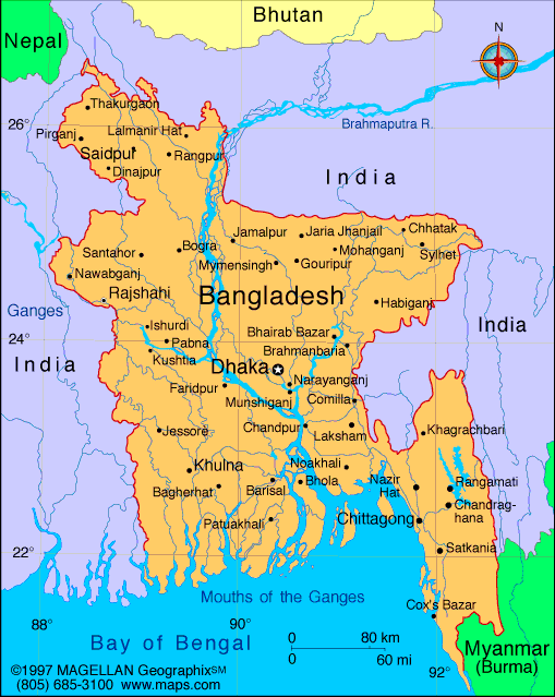
Bangladesh is a populous country on the northern coast of the Bay of Bengal. It is surrounded by India, with a small southern border with Myanmar. The country is low-lying, with many branches and tributaries of the Ganges and Brahmaputra rivers, making up the largest river delta in the world. Tropical monsoons, flooding, and cyclones frequently inflict heavy damage in the delta region.
Bangladesh is part of the historic Bengal region of the northeast part of the Indian subcontinent. The earliest reference to the region was to a kingdom called Vanga, or Banga, in 1000 B.C. Buddhists ruled for centuries, but by the 10th century Hinduism became the main religion of the area. During the 15th century Bengal (Bangladesh) became part of the Mogul Empire and entered the Islamic world. It is now the world’s 3rd largest Muslim nation, behind Indonesia and Pakistan.
Formally East Pakistan, Bangladesh was established as its own country in 1971 after a war of independence against Pakistan. It is one of the most crowded countries on Earth, with more than 2,600 people per sq. mi. Poverty is widespread, and almost half of the population lives on less than $1 a day. Cotton textiles, jute, garments, and tea processing are its major industries, while rice, jute, tea, wheat, and beef make up the majority of its agriculture.
Chile
Quick Facts:
-President: Sebastían Piñera (2010)
-Government: Republic
-Population: 17,067,396 (2012)
-Growth Rate: .88%
-Land Area: 289,112 sq. mi.
-Capital & Largest City: Santiago, pop. 5,833,000 (2009)
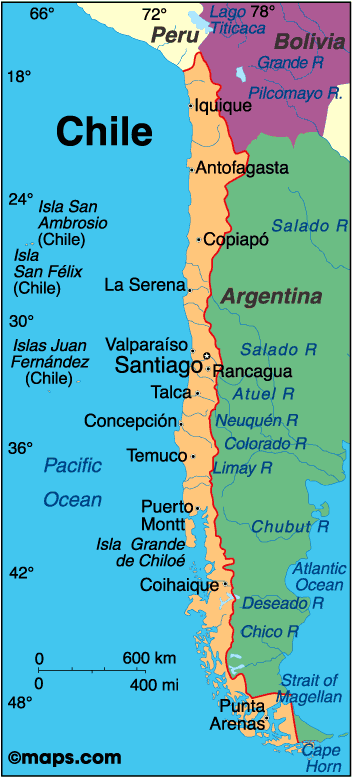
Chile is situated south of Peru and west of Bolivia and Argentina in South America. It fills a narrow, 2,880 mi. strip between the Andes and the Pacific. 1/3 of Chile is covered by the towering Andes Mountains, and the north consists of the driest place on Earth, the Atacama Desert. In the center of the country lies a 700 mi. long valley which is thickly populated and has most of Chile’s arable land.
Chile was originally inhabited by the Incas in the north and the nomadic Araucanos in the south. In 1541, a Spaniard, Pedro de Valdivia, founded Santiago and Chile was under Spanish rule until it won its independence in 1818. Throughout the years, Chile expanded its territories by winning wars with Peru (1836-1839) and Peru and Bolivia (War of the Pacific, 1879-1883).
Today, most Chileans are of European or mixed European/ indigenous ancestry- only about 5% are indigenous. It is a highly urbanized country, with 40% of the population living in the Santiago area. Privatization of industries and increased agricultural exports have boosted the economy in recent years, and the Chuquicamata and Escondida copper mines in the Atacama Desert are the world’s largest. Tourism is another major business, as is the mining of minerals, foodstuffs, fish processing, iron, and steel. Wheat, corn, grapes, beans, fish, and timber are its major forms of agriculture.
India
Quick Facts:
-President: Pranab Mukherjee (2012)
-Prime Minister: Manmohan Singh (2004)
-Government: Federal Republic
-Population: 1,205,073,612 (2011)
-Growth Rate: 1.312%
-Land Area: 1,147,949 sq. mi.
-Capital: New Delhi, pop. 21.72 million (2009)
-Largest City: Munbai, pop. 19.695 million (2009)
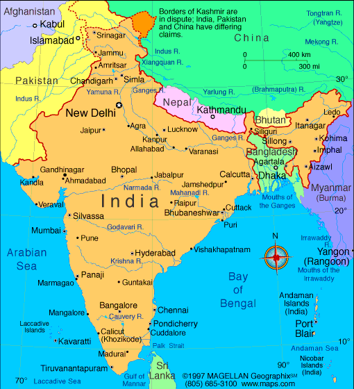
1/3 the size of the United States, the Republic of India occupies most of the subcontinent of India in southern Asia. Its neighbors include China, Pakistan, Nepal, Bhutan, Burma, and Bangladesh. The country can be divided into 3 distinct geographic regions: the Himalayan region in the north, which contains some of the highest mountain peaks in the world, The Gangetic Plain, and the plateau region in the south and central part. Its 3 river systems- the Ganges, the Indus, and the Brahmaputra- all have large deltas and rise in the Himalayas.
One of the earliest civilizations, the Indus Valley civilization, flourished in present-day India from 2600-2000 B.C. Buddhism was founded in the 6th century B.C. and spread throughout northern India. Islam also became established in the 1500s A.D. when Muslim invaders founded the great Mogul Empire, centered around Delhi, which lasted until 1857. In the 1600s the British founded the East India Trading Company and also established rule of India in 1687 with Bombay as its capital. India did not gain full independence until 1947 after WWII, with the help of Mahatma Gandhi.
Today, India is 2nd to China in world population, but is growing faster and is set to be the most populous country on Earth by 2030. Its main religion is Hindu, with 81% of the population, but there is also one of the largest Muslim populations in the world at 138 million. The Hindu caste system reflects Indian economic and religious hierarchies. 1 out of 6 Indians suffers the lowest caste as “Untouchables” and experience serf-like conditions in rural areas. Despite this however, India has a burgeoning middle class and has made great strides in engineering and information technology. Its main forms of industry include textiles, chemicals, food processing, steel, transportation equipment, cement, and mining, while rice, wheat, oilseed, cotton, cattle, and fish make up the bulk of its agriculture.
Nigeria
Quick Facts:
-President: Goodluck Jonathan (2010)
-Government: Multiparty government transitioning from military to civilian rule.
-Population: 152,217,341 (2010)
-Growth Rate: 1.9%
-Land Area: 351,649 sq. mi.
-Capital: Abuja, pop. 756,100 (2003)
-Largest City: Lagos, pop. 16,821,000 (2003)
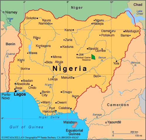

Nigeria is 1/3 larger than Texas and is the most populous country in Africa. It is situated on the Gulf of Guinea in West Africa and is neighbors with Benin, Niger, Cameroon, and Chad. The terrain changes from the oil-rich Niger Delta in the south, to a belt of rainforests inland and high savanna-covered plateaus in the north.
The 1st inhabitants of what is now Nigeria were thought to have been the Nok people in 500-200 A.D. Various empires and peoples ruled the area until the British formally seized control of the country in the mid 1800s. A century of British rule ended in 1960. After independence, a deep rift formed between the poor north and the more prosperous south, resulting in a civil war from 1967-1970. Even once the war ended, decades of military coups and military rule ensued until 1999 when Nigeria held its 1st democratic election.
Nigeria’s population is extremely diverse, with some 250 ethnic groups. The 3 largest ethnic groups are: Hausa-Fulani (29%), Yoruba (21%), and Igbo or Ibo (18%). Northern Nigeria is mostly Islamic and dominated by the Hausa-Fulani. Southern Nigeria is more westernized/urbanized, with the Yoruba, ½ Christian and ½ Muslim, in the southwest and the Ibo, Christian/Roman Catholic, in the southeast.
Since the oil boom of the 1970s, Nigeria has had an unhealthy dependence on crude oil. In 2002 oil and gas exports accounted for 98% of its export earnings and provided 83% of the federal government’s revenue. Other industries besides crude oil include coal, tin, columbite, palm oil, peanuts, cotton, rubber, hides/skin, and textiles. Nigeria’s agriculture suffers mismanagement and corruption, but still manages to produce cacao, peanuts, palm oil, corn, cattle, timber, and fish.
Information: http://travel.nationalgeographic.com/travel/countries/
All images: http://www.infoplease.com